
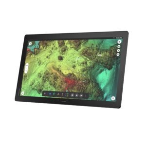

Garmin GPSMAP 1623 16″ Marine Chartplotter Display
Sampling 10Hz multi-band satellite fixes without position jumping, a Garmin GPSMAP 1623 GNSS receiver plots Navionics+ coastal charts on a 15.6-inch 1080p IPS touchscreen, networking OneHelm and J1939 engine telemetry across an IPX7 chassis.
- 10Hz multi-band core eliminates position lag
- 15.6-inch Full HD panel ensures clarity
- OneHelm interface coordinates digital vessel switching
$2,964.59
Availability
In stock and available to order
Bulk order support
Request for Quotation
Free standard shipping to eligible destinationsSecure checkout
On a 30-foot sportfisher or fast cruiser, there is a point where a normal 12-inch display stops being enough for safe, comfortable split-screen work. The Garmin GPSMAP 1623 gives the helm a 15.6-inch Full HD chartplotter display with preloaded Garmin Navionics+ coastal and inland mapping. It is aimed at boats that need charts and system data clearly visible from a standing position.
Its 10Hz multi-band positioning core matters when following a route at speed, because the display receives more frequent position updates than a basic GPS plotter. The 1920 x 1080 IPS screen gives chart details and data panels more separation, while Garmin Marine Network, NMEA 2000, NMEA 0183, J1939, and OneHelm connections support a wider helm system. This model is chartplotter-focused; the supplied specifications do not list built-in sonar or a transducer, so fishfinding needs separate compatible hardware.
Who Is This For?
This large marine chartplotter display suits 26- to 55-foot offshore fishing boats, high-performance cruisers, and premium multi-display dashboards. It is not ideal for a compact helm or anyone expecting an included fishfinder; no built-in sonar or transducer is listed.
Warranty & Support
The supplied specifications do not state a warranty term. Confirm current Garmin warranty coverage before purchase.
The GPSMAP 1623 sits between compact MFDs and full glass bridge displays. It is the right choice when a large chart screen is more important than an included sounder. The trade-off is system planning: Garmin Navionics+ mapping is already there, but sonar hardware must be selected separately. That makes it a better fit for a planned premium helm than a quick fishfinder replacement.
Product Specifications
Product Specifications
| Brand | Garmin |
|---|---|
| Full Model SKU/Code | 010-02861-00 (GPSMAP 1623) |
| Country of Origin | Taiwan |
| Device Type | Fixed-Mount Marine Chartplotter Multi-Function Display (MFD) |
| GNSS Systems Support | GPS, GLONASS, Galileo, QZSS, BeiDou |
| Receiver Channels & Frequency | High-Rate 10 Hz Multi-Band Positioning Core |
| Preloaded Marine Charts | Garmin Navionics+ Coastal and Inland Mapping Arrays |
| Display Technology & Resolution | Bright Full HD (FHD) In-Plane Switching (IPS) Multi-Touch Screen / 1920 x 1080 |
| Screen Size | 15.6" Diagonal Window Display Surface |
| Interface Type | Capacitive Multi-Touch Interface Screen |
| Waypoint & Route Capacity | 5,000 Waypoints / 100 Routes |
| Internal Memory & Expansion | Integrated Internal Flash Memory / Dual MicroSD Card Slot Hub Layout |
| Operating Voltage | 10 to 32 Volts DC Universal Rail Interface |
| Data Networking Protocols | Garmin Marine Network Ethernet (Multiple Ports), NMEA 2000, NMEA 0183, J1939 Engine Can Bus, OneHelm Connectivity |
| Waterproof & Floating Rating | IPX7 Waterproof Protection Architecture |
| Maximum Current Draw | 3.3 Amps at 12V DC Input Loop (Max Power Draw: 46.5W) |
| Dry Weight | 4.4 kg / 9.6 lbs |
| Application | Main command consoles on mid-to-large offshore fiberglass fishing hulls, high-performance cruisers, and multi-display premium dashboards (26-55 ft hulls) |
Related Products


Payment Protection
Checkout will use the selected PayPal or Stripe payment method.
Free International Shipping
Free standard delivery to the United States, Canada and Australia.
Product Support
Ask for product and compatibility information before ordering.


Reviews
There are no reviews yet.